
 |
| The rain clears at last. |
Thursday 11 November 2010
Old Map
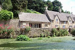
The rain is teeming down outside and the cars are sploshing down the road. The shop is very quiet at this time of year and it has given me time to study an old map of the village which was hand drawn in 1769. The copy I have was kindly given to me by a friend, who procured it from the County Records Office. The one thing that is most striking about the map is how few buildings there were in the village at the time. The Church [of course], the Bibury Court, Arlington Mill and Arlington Manor are the most prominent ones and then there are a few cottages scattered here and there. Arlington Green was then a collection of four or five houses and seems very different from the hotch potch of cottages that it became in later years. It makes me realise how busy the village was during the last part of the eighteenth century, when most of the village seems to have been constructed. It appears that the village boomed during these years of the Agricultural Revolution and it must have been a noisy, bustling place and far from the rural idyll that we often project onto the past.
Subscribe to:
Post Comments (Atom)
Richard. Greetings. My grandparents and parents lived in Arlington Mill certainly from the 1930's to around 1970 when my Nan (Brownett) died in Fairford hospital. My Mum & Dad were married in RAF uniform in Bibury church in 1948. I would be very interested in getting a copy of the old 1769 map, how could I do that? Derek
ReplyDelete